
Runs and Snow
Drawing
Section titled “Drawing”Hub Runs tab > Run tile > area tool, drawn from the lift top downhill.
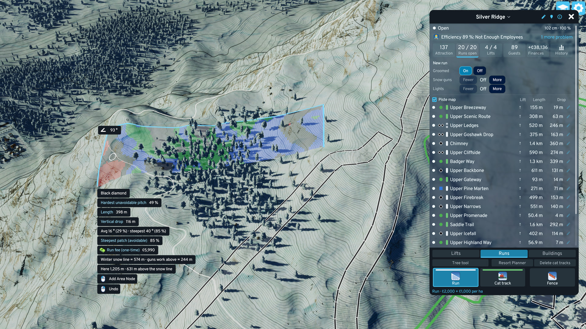
- Linking: a run drawn within the ski area radius (5 km by default) of a Welcome Sign links to that ski area, and stays linked if the radius changes later. Option Link runs the moment they are drawn, default on.
- Feedback: slope heat-map, contour lines, and a tooltip with the rating, hardest unavoidable pitch, length, vertical drop and the average and steepest slope.
- Heat-map colors: North American: gray flat, green, blue, black, red double black. European: gray flat, green, blue, red, black, orange ski route.
Rating
Section titled “Rating”Rating = slope of the hardest unavoidable pitch: the crux of the easiest line from run top to run bottom. A flat runout cannot hide a steep pitch, and one corner on a bank cannot make a double black.
| Slope of that pitch | North American | European | Worth (before size and type) |
|---|---|---|---|
| under 3.4° | Flat (unrated) | Flat (unrated) | 0 |
| 3.4 to 8.5° | Green circle | Green piste | 6 |
| 8.5 to 14° | Green circle | Blue piste | 6 |
| 14 to 21.8° | Blue square | Red piste | 12 |
| 21.8 to 31° | Black diamond | Black piste | 20 |
| 31° and over | Double black diamond | Ski route (orange) | 28 |
- Grading: option Run grading (Options > Modular Ski Resort > Ski Resort hub): Auto (the city’s map theme), North American or European. It changes names, markers and colors only. A European green and blue piste are the same band and score the same.
- Short steep pitches: a borderline black or double black rates one band easier when little of the run is that steep, unless the pitch is 40 m or longer or the run is under 20 m wide there. A run averaging under 14° rates at most blue (European: red), unless its steep pitch is 40 m or longer.
- Cannot be rated: outline too large, too thin or without terrain. Worth 3.
- New run: counts 0 until rated. A reshaped run keeps its last rating while it is rated again.
- Size factor: bigger runs are worth more, with diminishing returns: 1 at 2 ha, the cap 2 at about 56 ha. Values: Attraction Formula.
Run Features
Section titled “Run Features”While the Run tile is active, the New run rows at the top of the Runs view set the next run’s features. Groomed: On or Off. Snow guns and Lights: Off, or the distance between them. Both need Groomed. For a built run, select it in the Runs list to change them.
Groomed off. Surface: none drawn (visible on the piste map). Opens on natural snow only. Value: green ×0.5, blue ×0.75, black ×1. Build fee: 500 + 250 per ha. Upkeep: none.

Surface: groomed snow. Value: full when open. Build fee: 2,000 + 1,000 per ha. Upkeep: 150 per ha per month while snow-covered, also while its snow guns are stopped because the snow is deep enough.
Adds: snow guns where the air is cold enough: the run opens earlier and stays open longer. Build fee: +2,000 + 3,000 per ha. Upkeep: +350 per ha per month where the guns make snow.
Adds: floodlights. Value: ×1.25 of groomed. Build fee: +2,000 + 3,000 per ha. Upkeep: +300 per ha per month while snow-covered.
Role: link across the hill. It carries lift service to the runs it meets lower down (see Lift Service). Graded no steeper than 14° by the cat track tool, so always rated green (European: green or blue). It counts a quarter of a run its size in score and capacity, and crosses other runs without changing them. Pricing: as groomed. Upkeep, per ha of plan area per month: grooming 150 while its guns can run, snowmaking +350 only while the guns make snow. Lights add 300 in its snow season, guns on or off, and change only the look. Snow guns: on one side of the ribbon. Their snow counts toward opening the track but is not painted on it: the game’s snow map is too coarse for a track this narrow.
- Paid once: a feature’s fee is charged the first time it is on, by the run’s area. Turning it off refunds nothing. Turning it on again, changing a distance and reshaping a run are free.
- Groomed on a built run: the run keeps its name, ski area, snow guns, lights and trees.
- Names: a new run gets a trail name that fits it from a list of 200 (a black Chute, a green Meadow, a cat track Road, Upper … near the top). No two runs share a name while one is free, then it is Run N. A rename wins.
Cat Track Tool
Section titled “Cat Track Tool”Lay out the track and press Enter. The tool cuts and fills the ground so the track never climbs steeper than the max slope you set, then builds the cat track on the graded strip.
-
Open: hub Runs tab > Cat track, or Ctrl+Shift+K. Click points up the hill. Right click or Esc steps back one point. Neither ever removes a built track.
-
Branch: a click on an existing cat track starts a new track there.
-
Delete: hub Runs tab > Delete cat tracks, or Ctrl+Shift+D while the tool is open. Click a track once to arm it (red), again to delete it. Or the trash button on its row in the Runs list, clicked twice within 4 seconds. The ground stays as graded and the fee is not refunded. The bulldozer cannot pick a cat track.
-
Ski way: hub Runs tab > Ski way, or Ctrl+Shift+J while the tool is open. The next tracks are ski ways: 10 m wide, cut into the hillside with a 1:1 bank, nothing filled below. For steep faces where a full-width track would need a tall fill. Your max slope still applies. The width, cut and fill settings do not. The chip stays lit until you switch back or load a save.
-
Settings (Options > Modular Ski Resort > Runs):
Setting Default Range Max slope 14° 3 to 14°, step 0.5 Width 20 m 8 to 32 m Cut slope 1:1.5 1 to 3 Fill slope 1:2 1 to 4 -
Cost: grading is free, like vanilla terraforming. The track pays the cat track fee.
-
Refused: a path that cannot stay under the max slope (the tooltip gives the missing length: add a switchback), legs closer than the track width, a graded strip under a building or station, in water or within 6 m of a lift line, and two overlapping cat tracks.
-
Constant grade: off, the track follows the ground and moves as little earth as the max slope allows. On: one even slope from end to end.
-
Crossing runs: the crossed run keeps its own slope and difficulty. It is graded at most 2 m along the track, fading out toward its edges, and the grading fades in over the 15 m before the run. If that would change the run’s difficulty, the tool grades less or refuses. Where 2 m is not enough the plan turns red: cross more level, not down the fall line.
-
Terrain: trees in the corridor are removed (not inside a crossed run). Runs are rated again after the terrain changes.
-
Before lifts: grading changes the ground, so a cat track can never pass under a lift that is already built. Build the track first, then the lift over it.
Resort Planner
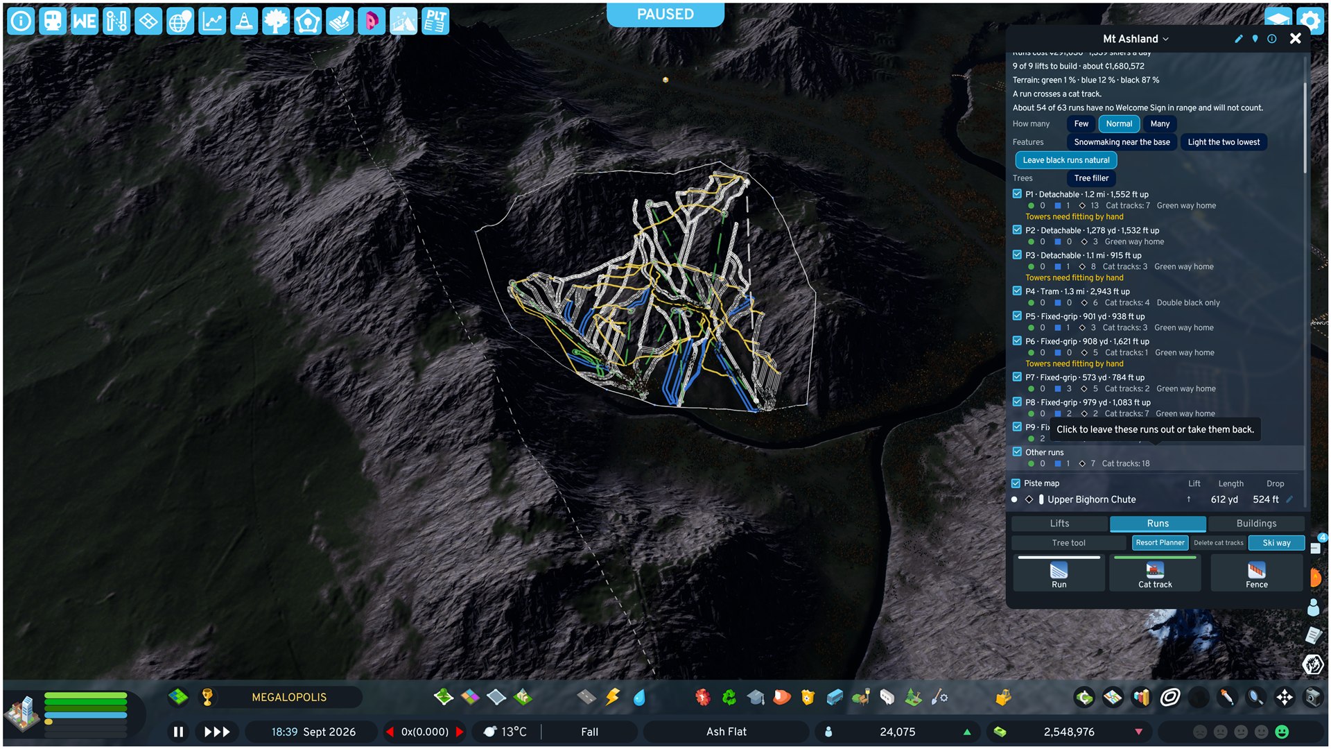
Section titled “Resort Planner”Outline a region and the planner lays out linked runs and cat tracks, then the lifts that serve them. You review and change the plan. Build makes the cat tracks and runs. Build lifts then adds the lifts. On by default. Its switch: Options > Modular Ski Resort > Runs > Resort Planner.
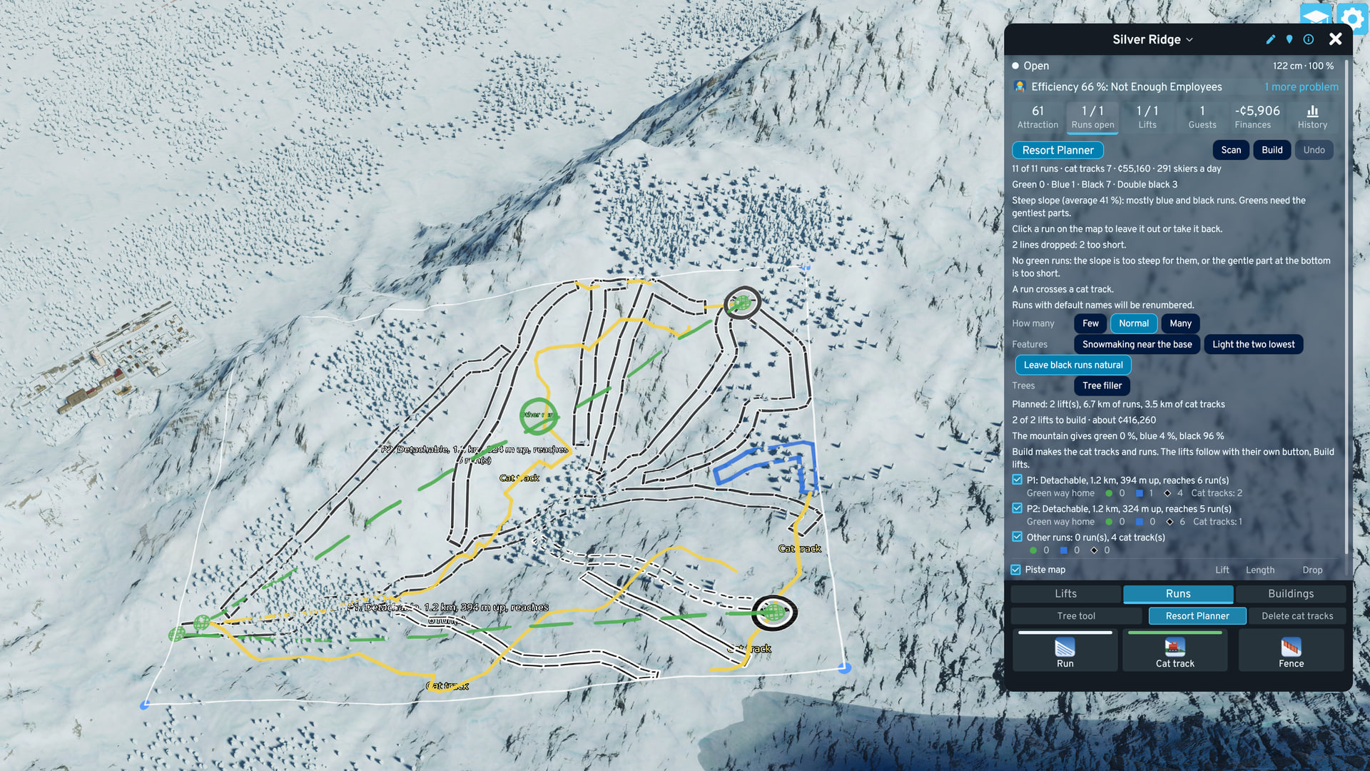
- Open: hub Runs tab > Resort Planner, or Ctrl+Shift+Q.
- Steps: a strip at the top of the planner shows the order: Region, Scan, Build runs, Trees, Lifts. Trees come before lifts because a lift line clears the trees in its path when it builds.
- Outline: click the corners, then the first corner again to scan. From 4 ha up to 9 km² (about 3 x 3 km), corners no wider apart than about 5 km. Click an edge to add a corner.
- Around a lift: with no corner placed, click the station of a lift that has its line. The outline becomes 150 m on each side of the line plus 400 m down the fall line below the base station.
- Site verdict: the average slope of the outlined ground. The ranges are gentle (under 14°), steep (14 to 24°), very steep (24 to 30°) and steeper than any real ski area (30° and up).
- Scan: runs in the background, about half a minute for a large region. Right click stops it, moving a corner starts it again. A scan that finds nothing says why.
- The plan: each proposed lift is a dashed line with its towers and station spots, colored by its way home. A ring at its top marks its group: the runs that start from it. Runs show in piste-map colors (natural runs dashed), cat tracks as yellow center lines. The hub lists one row per lift with its length, rise, runs and way home. Builds, with one tower over its limit and Needs fitting by hand are explained under Lifts below.
- Way home: for each lift, the easiest way on skis from its top to the bottom of a lift that starts in the base area. A gondola or tram top also counts: guests ride it down. Verdicts range from Green way home to No way down on skis: ride the lift down.
- Way to the bottom: the planner also looks for a run or cat track of any rating from every lift top to the bottom of the region. It warns when some lifts have none.
- Pick: click a run to leave it out (gray) or take it back. Click a lift’s line, ring or hub row to do the same for the lift and its group’s runs.
- Knobs: How many (Few, Normal, Many). Few leaves out the runs between the main lines. Many adds little over Normal. Features: Leave black runs natural (black and harder runs ungroomed, no grooming fee or upkeep), Snowmaking near the base (green runs that reach the base get snow guns. European: green and blue), Light the two lowest (up to two base runs, blue or easier, get lights and snow guns. European: red or easier). Every other run is groomed.
- Build: Build or Enter. Refused when the city cannot pay the runs and the switched-on lifts together. If the map changed since the scan, it scans again first. Cat tracks are built first, then runs, a few at a time. They link and pay like runs you draw. A run the game refuses turns red and is left out. Stop or right click stops after the runs in progress. Closing the tool stops too, and what is built stays without Undo.
- Lifts: Build lifts adds every switched-on lift not yet built, from the lowest base up: base station, top station, then the line. A lift the city cannot pay for is skipped. A line with one tower up to 5° over its sheave-train limit is built anyway. A line the planner cannot fit gets its two stations only. After the other lifts, the lift tool opens on it: move or add towers and press Enter. When the lift tool closes, the Resort Planner opens again with its region and lift list. The planner places no power line: each base station still needs its low-voltage line. Until a lift serves them, its runs count as backcountry.
- The lift list: the Runs view keeps the planned lifts with their cost and state until the next scan or load, also while the planner is closed. A long list scrolls. A row’s Build makes that one lift, Stop stops after the lift in progress, Clear list removes the rows (built parts stay). A row also turns Built when you draw that lift by hand between its stations.
- Undo: removes the cat tracks and runs of the last build, refunds them and scans again. Check the runs before Build lifts, which ends Undo. After that, the bulldozer removes runs one at a time and refunds no run fee.
- Warnings: among others: lift tops with no way down on skis, a run that ends where nothing continues, a build the city cannot pay, runs in more than one ski area and the game’s checks being off (Anarchy). Another warning is no Welcome Sign in range. Those runs count only once a sign is placed nearby.
- Trees: Tree filler fills the region with trees around the runs, up to a tree line that starts where the wild trees nearby stop (move it 10 or 50 m at a time). Pick Conifer (default), Deciduous, Palm, All trees or one species, and a density. Plant (or Enter) plants 2,000 at a time until the region is full, and removes filler trees a lower density or tree line no longer wants. Undo trees works until the planner closes. A scan or a build turns the filler off. The filler keeps out of every built lift’s tree corridor. Filler trees count as wild trees: a run drawn over them later can clear them.
- A scan that stops with an error: see Troubleshooting.
Snow Conditions
Section titled “Snow Conditions”Snow is measured per run from the game’s snow simulation. The same rule applies to every run: natural or made snow, every rating.
| State | Snow on the run |
|---|---|
| Open | at least 91 cm on 60 % of the run |
| Patchy | between open and closed. Counts part of its value. |
| Closed | an open run closes once less than 30 cm covers 40 % of it. It opens again at 91 cm. |
- Snow guns: work where the air is at most 3.3 °C above freezing (option Snowmaking margin). Higher margin: longer season, higher snowmaking bill.
- Gun depth: the guns start when the run falls under 91 cm and stop at 96 cm, so the run stays open between restarts.
- Gun season: from 2 months before winter to 1 month after (October 1 to April 1 for a December to February winter). No guns, bill or plume outside it. Where the game’s own season reads Winter the guns run, where it reads Summer they do not, whatever the date.
- Spacing: guns, hydrants and floodlights stand along a run’s edge: Off or 20 to 200 m, per run. A cat track starts with snow guns at 60 m and lights Off. Off means no guns or lights and no upkeep for them. Snow already made stays until it melts. Each prop can be bulldozed and stays gone until the outline or a value changes.
- Cat tracks: the same open and close depths as a run. Its made snow is not drawn but counts: its guns build 91 cm in about 1 game hour. Made snow outlasts a warm spell for up to 72 game hours (36 in spring, none above 10 °C). A cat track closes last.
- Powder day: fresh snow in the last 24 hours. More locals go skiing. See Passes and Lessons.
- Units: the docs are metric. The hub shows snow depth and temperature in the units of option Weather (Auto follows the game’s setting).
- Run text: an open run’s line names the depth that keeps it open: Open: 100 % of it has at least 30 cm of snow. A closed run’s line names the depth that opens it. A patchy run’s line names no depth.
- Estimated snow: after a save load, or for a new sign, snow is estimated from the day’s temperature until the first measurement. Marked ≈, and the run line says estimated from the day’s temperature.
- No open run: the ski area counts as summer sightseeing. Lodges and lifts count at a reduced share. After one game hour with no open run, chairlifts and gondolas stop. The aerial tram keeps running as sightseeing.
Lift Service
Section titled “Lift Service”A run reaches full value only while a lift serves it. See Lifts for building one.
- Served: a complete, powered lift reaches the run top (the highest point of the outline).
- Chairlift and gondola: the lift line passes within 150 m of the run top, and the run top is at most 15 m above the top station.
- Aerial tram: the run top is within 300 m of the top terminal and at most 15 m above it. Not along the line.
- Linked runs: a run is served too when skiers can get onto it downhill from a served run in the same ski area. The outlines come within 25 m or overlap, and at least 30 m of the run (or a third of its drop, if less) lies below the junction. Touching only at its own bottom does not count. Service never flows uphill, and a chain of linked runs is served from one lift.
- Cat tracks: skiers get on where a cat track meets a served run and ride it either way, as long as it never takes them more than 3 m above where they got on. It serves the runs it meets below that point.
- Backcountry: no lift serves the run. Counts 40 % of a served run (option Backcountry run value).
- Ski patrol: raises backcountry runs near an active patrol building to at least 70 %. See Lodges, Ski School and Patrol.
Glades
Section titled “Glades”Tree tool: plans trees on and around runs. Hover a run, click.
- Toggle: Ctrl+Shift+G.
- Tree density: Shift+G steps 1 (clears the run) to 8 (thick forest).
- Mode: Alt+G switches run interior / tree line along the edge.
- Cat tracks: the Tree tool plans ski runs only. A cat track’s top is cleared of trees when it is built.
Piste Map
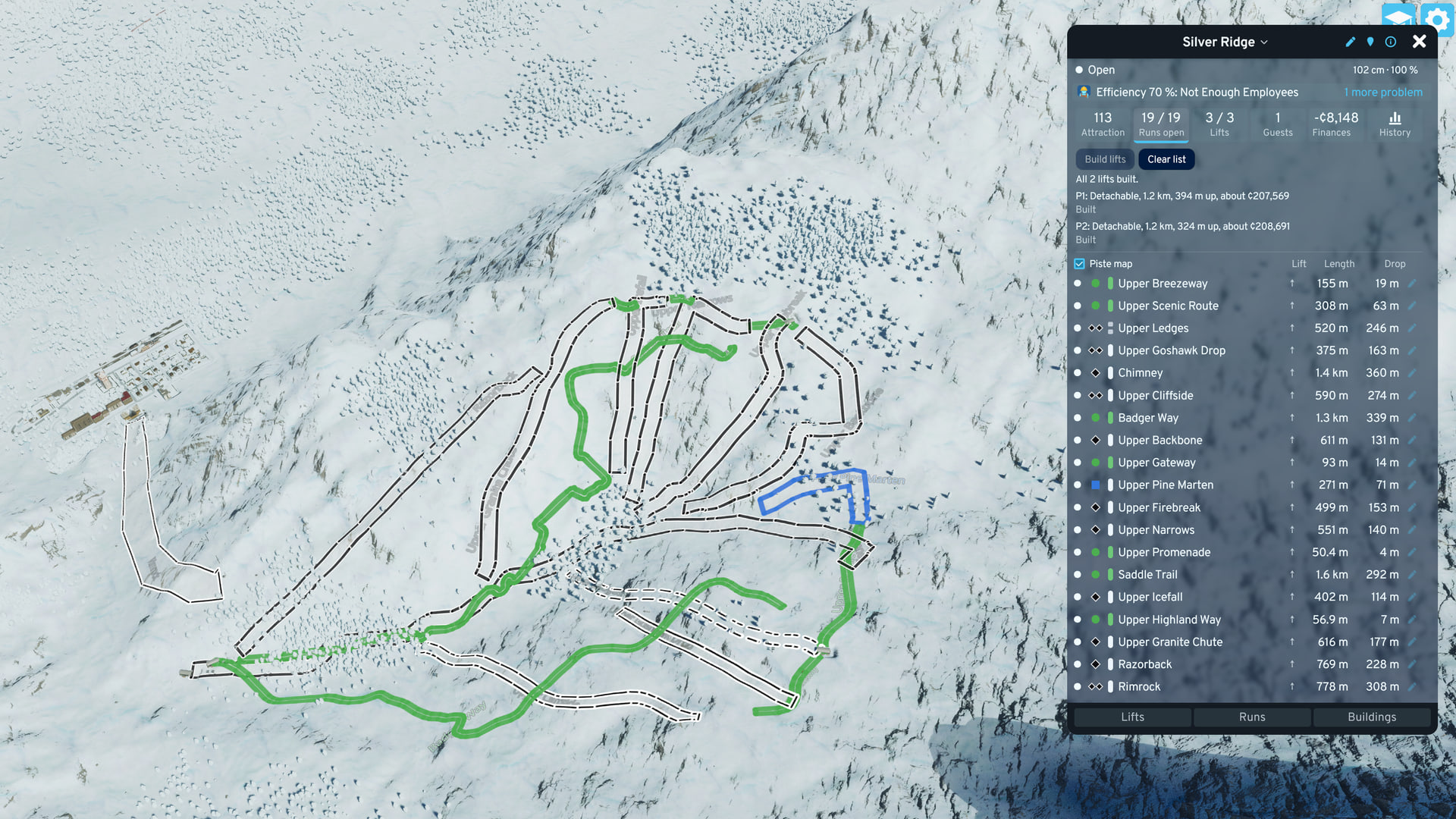
Section titled “Piste Map”Hub Runs view check box Piste map: draws the shown ski area’s runs on the ground in difficulty colors while the hub is open. It is hidden while the Tree tool or the Resort Planner is open.
- Colors: the run grading’s colors. European grading adds red pistes and orange ski routes with a black edge.
- Natural runs: dashed.
- Too flat: gray.
- Cannot be rated: pale orange, no edge.